Honestly, if you look at a standard Game of Thrones map the North looks like a massive, empty wasteland where nothing happens but shivering. It’s huge. It’s roughly the size of the other six kingdoms combined, which is a wild geographical fact that the show sometimes struggled to convey because of how fast Raven-mail seemed to travel in later seasons. George R.R. Martin has basically said the North is about the size of South America, though in the context of the show’s logic, it feels a bit more like a frozen version of Canada.
Size matters here.
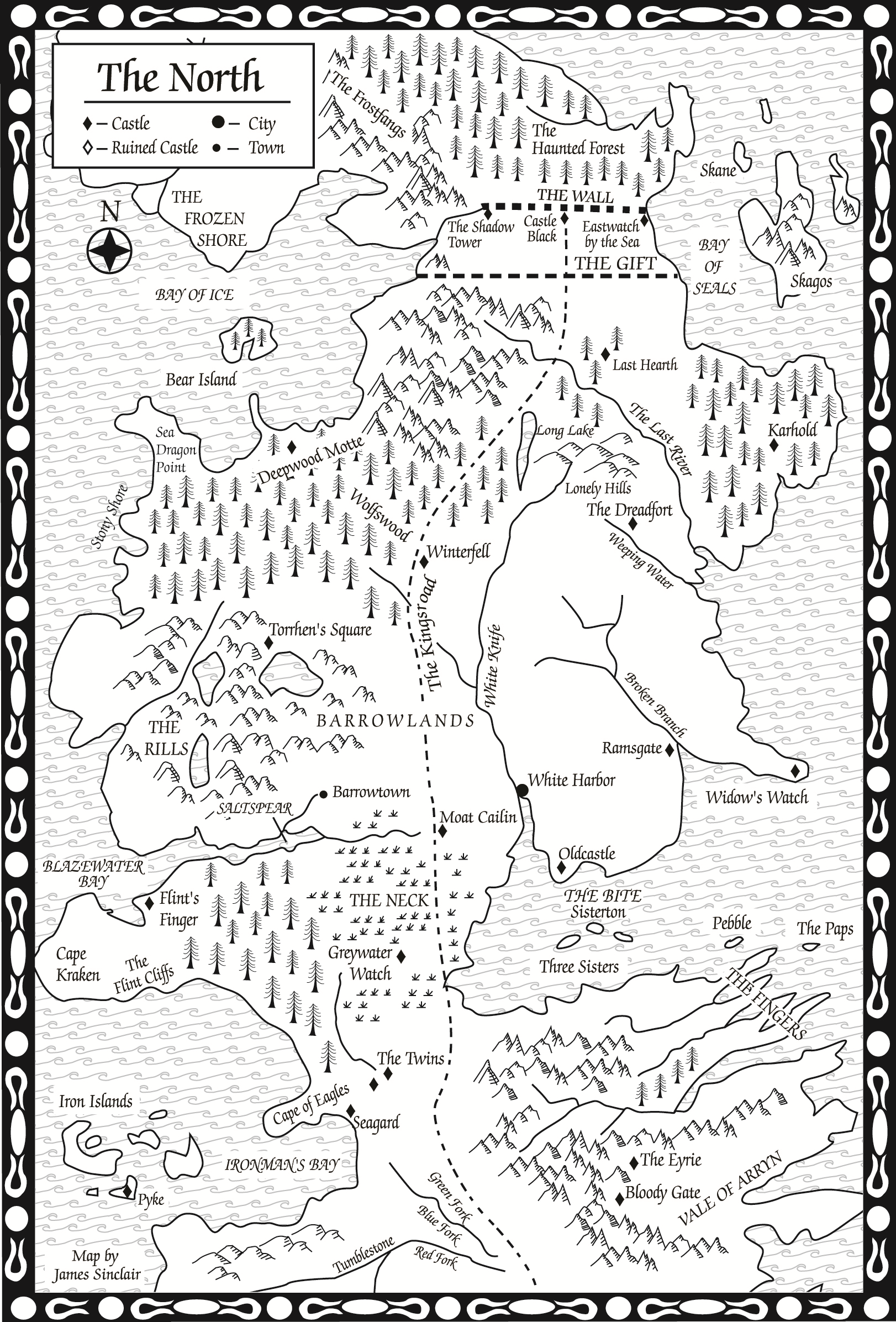
When you’re staring at that jagged coastline and the massive stretch of the Kingsroad, you’re looking at a region defined by isolation. The North isn't just a place; it's a logistical nightmare for anyone trying to rule it. From the Neck up to the Wall, the sheer distance dictates the culture. It’s why the Starks are so "different"—they have to be. You can't run a kingdom that big with a light touch. You need loyalty that’s as hard as the ice on the Long Lake.
Mapping the Scale of Winterfell and Beyond
If you’re trying to navigate a Game of Thrones map the North starts at the Neck. This is a swampy, miserable chokepoint. It’s the only land route into the region. Most people ignore the Crannogmen and House Reed, but on a tactical map, Moat Cailin is the most important pile of rocks in Westeros. It’s effectively a valve. If the Starks don’t want you coming up the Kingsroad, you aren’t coming up.
North of the Neck, the map opens up into a vastness that is honestly terrifying.
You have the Barrowlands to the west, full of the graves of First Men kings. To the east, you have the White Knife river, which is the literal lifeblood of Northern trade. White Harbor sits at the mouth of it. It’s the only "real" city in the North. If you’re looking at the map and wondering where the money comes from, it’s there. House Manderly is filthy rich because they control the only deep-water port that doesn't freeze solid for half the year.
Winterfell sits right in the middle. It’s not just a castle; it’s a geothermal anomaly. Built over hot springs, the walls stay warm even when the snow is ten feet deep. On a map, it looks like a central hub, and that’s exactly what it is. It’s the heartbeat. Every major road and track eventually trickles back to the Winter Town.
The Wolfswood and the West
To the northwest of Winterfell lies the Wolfswood. It’s massive. It’s one of the largest ancient forests left in the world. On the Game of Thrones map the North shows this as a green blob, but for the people living there—like House Glover at Deepwood Motte—it’s a dense, dangerous larder and a fortress.
Further west, you hit the Stony Shore and Sea Dragon Point. These areas are sparse. They’re basically just wind-swept rocks and small fishing villages. In the books and the show, this is where the Ironborn love to cause trouble. Why? Because it’s too far from Winterfell for the Starks to send help quickly. If you’re an Ironborn raider, the geography of the North is your best friend. You can hit a village on the Stony Shore and be back at sea before a rider even reaches the gates of Winterfell.
The Wall: The Edge of the Known Map
At the very top of your Game of Thrones map the North ends at the Wall. 300 miles long. 700 feet high. It’s the literal edge of the world for most Southerners.
The geography here is bleak. You have the Gift and the New Gift—stretches of land meant to support the Night’s Watch. Historically, these were bustling with farmers and villages. Now? They’re ghost towns. When you look at the map, you see the abandoned castles of the Night’s Watch: Westwatch-by-the-Bridge, the Nightfort, Greenguard. Only three were manned at the start of the series: Castle Black, Eastwatch-by-the-Sea, and the Shadow Tower.
The Shadow Tower sits where the Wall meets the mountains—the Frostfangs. This is where the map gets vertical. It’s not just flat snow anymore; it’s jagged, impassable peaks. To the east, Eastwatch handles the shipping. If you’re looking at a map and trying to figure out how the Wildlings get around, they usually try to row around Eastwatch or climb the Bay of Seals. It’s a brutal bit of geography.
Beyond the Wall: The True North
Technically, the "North" as a political entity ends at the Wall, but the Game of Thrones map the North often includes the Lands of Always Winter. This is where the scale gets weird.
- The Haunted Forest: A massive woodland just north of Castle Black. It’s where the Rangers get lost.
- The Fist of the First Men: An ancient ringfort on a hill. It offers a 360-degree view of the surrounding wilderness, which is why the Great Ranging stopped there.
- The Skirling Pass: A winding mountain road through the Frostfangs. It’s the only way to move a large army (like Mance Rayder’s) through the mountains.
- Hardhome: A cursed, ruined fishing village on the Storrold's Point peninsula. On a map, it looks like a natural harbor, but in reality, it’s a graveyard.
Why the Geography Dictates the Story
The North’s map is why the Starks are so obsessed with "Winter is Coming." In the Reach, if you have a bad harvest, you buy grain from your neighbor. In the North, if the snows start falling and you’re caught on the road between the Last Hearth and the Dreadfort, you’re dead. Period.
The Dreadfort, ancestral home of the Boltons, is located on the banks of the Weeping Water. It’s a grim place. Geographically, the Boltons were always the biggest threat to the Starks because they controlled the eastern interior. They had the land and the men to rival Winterfell. When you look at the map, you see the tension. The Starks are in the center, the Boltons are to the east, and the Karstarks are even further northeast at Karhold. It’s a delicate balance of power held together by nothing but ancient oaths and the fear of a long winter.
The climate is the most important "character" on the map.
The North is the only place where the seasons dictate the borders. During a ten-year summer, the North feels manageable. During winter, the map shrinks. People huddle in the Winter Town or "the glass gardens" of Winterfell. The roads become impassable. The vast distances that make the North so impressive in the summer become its greatest weakness in the winter. You can't reinforce your bannermen if the Kingsroad is under twenty feet of snow.
Hidden Details: Skagos and the Lonely Isles
Look at the far east of your Game of Thrones map the North features a large island called Skagos. Most people forget it exists. The show barely mentions it. But in the lore, Skagos is part of the North—at least on paper. It’s a mountainous, terrifying island where people supposedly eat each other and ride unicorns (which are probably just giant, one-horned goats).
The fact that Skagos is even on the map tells you everything you need to know about Northern "rule." The Starks claim it, but they never go there. It’s too far. The sea is too rough. This is the recurring theme of Northern geography: claiming a land is easy, but actually controlling it is nearly impossible.
Real-World Insights for Fans and Cartographers
If you’re a fan trying to make sense of the Game of Thrones map the North is best understood through the lens of medieval Scotland mixed with Siberia.
- Logistics over Magic: Most of the "teleporting" characters in the later seasons of the show broke the map. For example, the journey from Winterfell to the Wall should take weeks, not a couple of days.
- The Importance of Water: In a land this big, rivers are the only way to move heavy goods. If a castle isn't near the White Knife or the Last River, it’s likely poor.
- Mountain Clans: The areas on the map that look like empty mountains (northwest of Winterfell) aren't empty. They are home to the Wulls, the Norreys, and the Liddles. They don't have big castles, so they don't get big icons on the map, but they can field thousands of warriors.
When you study the North, don't just look at the names. Look at the space between them. That empty space is where the Direwolves roam, where the White Walkers marched, and where the "Old Gods" still have power. The North isn't just a territory; it’s a wilderness that humans are barely allowed to live in.
To truly understand the North, you have to appreciate the sheer hostility of its layout. It’s a place designed to kill anyone who doesn't respect the cold. Whether you’re looking at the map to track Jon Snow’s travels or planning a tabletop RPG campaign, remember that the scale is the North’s greatest defense and its most brutal master.
Actionable Next Steps for Map Enthusiasts
- Compare Book vs. Show Maps: Take a look at the official maps in "A Knight of the Seven Kingdoms" or "The Lands of Ice and Fire." Notice how much more detail is given to the mountain ranges and the small keeps compared to the simplified TV show graphics.
- Track the Distances: Use the Wall as your scale. Since the Wall is roughly 300 miles long, use that length to measure the distance from Winterfell to King's Landing. It’ll give you a much better appreciation for why Robert Baratheon’s trip north in the first episode was such a massive undertaking.
- Explore the Fan-Made Interactive Maps: There are several high-quality, fan-created interactive maps online that allow you to toggle "spoilers" by episode or book chapter. These are the best tools for visualizing how the power dynamics shift across the North's vast terrain as the story progresses.